C-130H – Deployment of 8 Precision-Guided Suppressant Units
Cost per ha
52M KRW
·Labor: 6M KRW
·Equipment: 6M KRW
·Suppressant payload: 40M KRW
Response Time
20min
· 1 transport aircraft required
Agent per ha
8ton
Safety
·Pernonnel Required: 10
·Deployment Altitude: 100m
S-64E Helicopter – Deployment of 120 Tons of Water
Cost per ha
147M KRW
·Labor: 69M KRW
·Equipment: 78M KRW
Response Time
2 hours
·15 helicopters required
Agent per ha
120ton
Safety
·Pernonnel Required: 120
·Deployment Altitude: 15m
Wildfire (1 ha) Initial Response Cost and Time Comparison
Smoke
Smoke
Smoke
Nighttime
Nighttime
Nighttime
Buildings
Buildings
Buildings
Gusty Winds
Gusty Winds
Gusty Winds
Capable of tracking fire and smoke under various harsh conditions
① Object Detection
① Object Detection
① Object Detection

② Target Assignment& Sharing
② Target Assignment& Sharing
② Target Assignment& Sharing

③ Continuous Tracking
③ Continuous Tracking
③ Continuous Tracking

Target prioritization and continuous tracking technology
[Korean Patent Application Filed] 산불 대응 공대지 유도 소화장치 및 이의 제어 방법
[Korean Patent Application Filed] 산불 대응 공대지 유도 소화장치 및 이의 제어 방법
[US and PCT Applications Filed] Air to Ground Guided Wildfire Extinguishing Device and Control Method Thereof
[US and PCT Applications Filed] Air to Ground Guided Wildfire Extinguishing Device and Control Method Thereof
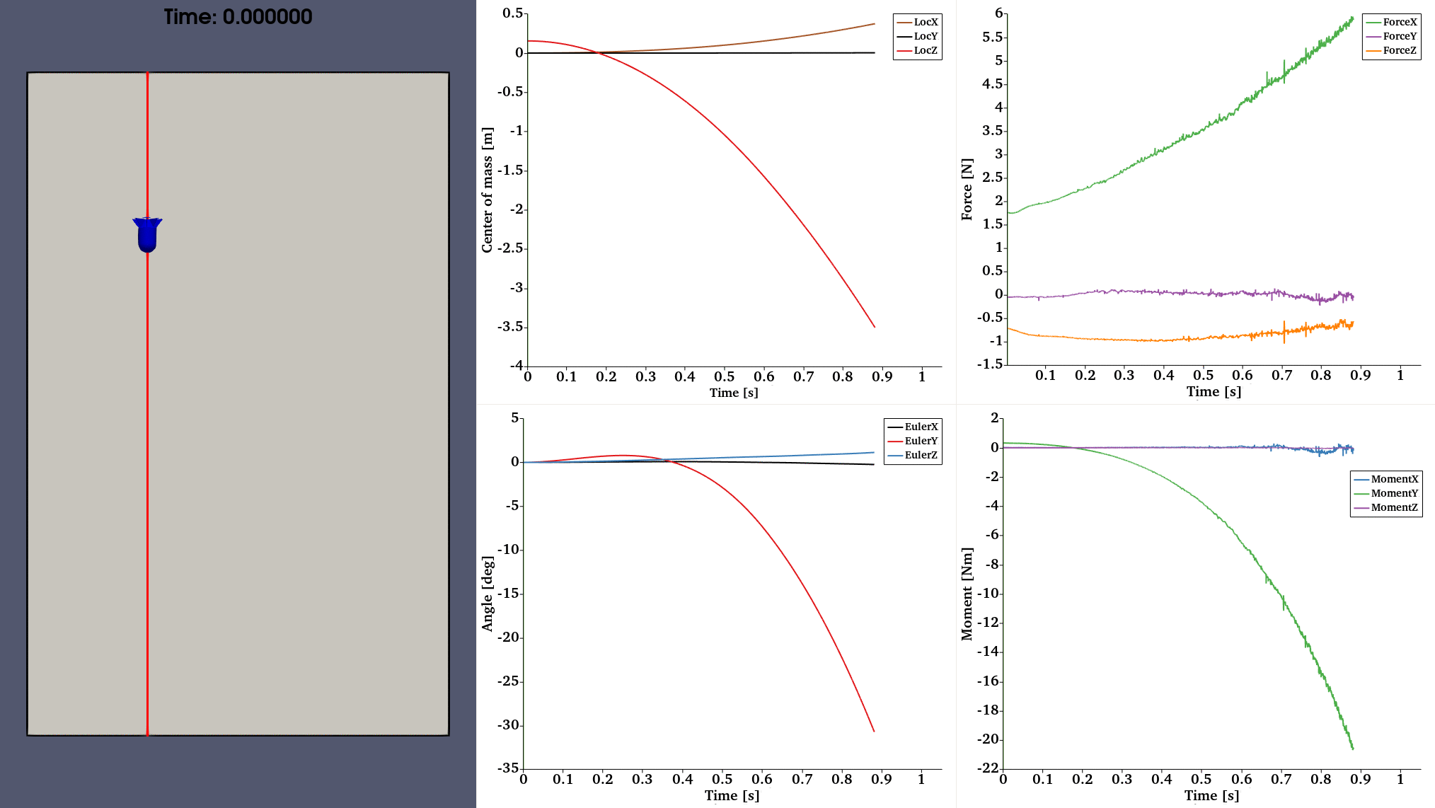

[CFD-Based Aerodynamic Analysis of Suppressant Payload Geometry]
[CFD-Based Aerodynamic Analysis of Suppressant Payload Geometry]
Accurate, precisely guided deployment allows suppressant payloads to reach target areas effectively, improving overall fire suppression performance.
Accurate, precisely guided deployment allows suppressant payloads to reach target areas effectively, improving overall fire suppression performance.
Accurate, precisely guided deployment allows suppressant payloads to reach target areas effectively, improving overall fire suppression performance.

We simulate wildfire spread in advance by integrating data on weather, terrain, and vegetation. Our ultimate goal is to build a digital twin of mountainous regions around the world, enabling us to learn from various wildfire scenarios and pre-plan the most effective firebreak strategies.
We simulate wildfire spread in advance by integrating data on weather, terrain, and vegetation. Our ultimate goal is to build a digital twin of mountainous regions around the world, enabling us to learn from various wildfire scenarios and pre-plan the most effective firebreak strategies.
We simulate wildfire spread in advance by integrating data on weather, terrain, and vegetation. Our ultimate goal is to build a digital twin of mountainous regions around the world, enabling us to learn from various wildfire scenarios and pre-plan the most effective firebreak strategies.
Using a deep learning system, we collect fire-related video data from global search results in multiple languages, enabling wildfire training tailored to each country's unique environmental context.
Using a deep learning system, we collect fire-related video data from global search results in multiple languages, enabling wildfire training tailored to each country's unique environmental context.
Using a deep learning system, we collect fire-related video data from global search results in multiple languages, enabling wildfire training tailored to each country's unique environmental context.
Contact us
foundation@deumeu.org
